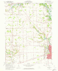
1961 Map of Piqua West
USGS Topo · Published 1973About this map
The Great Miami River and the historical Miami and Erie Canal anchor the industrial and agricultural landscape of western Piqua in the early 1960s. This survey illustrates the transition between urban development and rural township life, where the Pennsylvania and New York Central railroads intersect the river valley. The map reveals a dense network of civic and religious institutions, including Union Ch Church, Favorite Hill Sch, and several significant burial grounds such as Forest Hill Cemetery and Miami Memorial Cemetery.
Find a feature on this map
50 named features on this map. Tap any name to fly to it.
Don’t see what you’re looking for? This feature index may not catch every label — zoom into the map to look around manually.
Map Details
Editions of this 1961 Piqua West Map
4 editions found
Other maps of this area

1909 · Loramie
USGS Topo · 1:62,500

1911 · Loramie
USGS Topo · 1:62,500

1911 · Covington
USGS Topo · 1:62,500

1913 · Sidney
USGS Topo · 1:62,500

1914 · Troy
USGS Topo · 1:62,500

1944 · Covington
USGS Topo · 1:62,500

1944 · Sidney
USGS Topo · 1:62,500

1944 · Loramie
USGS Topo · 1:62,500

1944 · Troy
USGS Topo · 1:62,500

1953 · Muncie
USGS Topo · 1:250,000