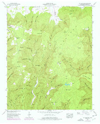
1948 Map of Pitcher Ridge
USGS Topo · Published 1977About this map
The Cumberland Plateau landscape dominates this 1948 topographic study, revealing a complex network of hollows and coves in Franklin County. Small community centers like Sal City and Lakeview are documented alongside numerous family-named landmarks that speak to the area's ancestral settlement patterns. The presence of Rowe Gap Church and Keith Spring Church, combined with well-dispersed burial grounds such as Rice Field Cem and Posey Field Cem, indicates a rural population living in the shadows of Pitcher Ridge and Bradford Mtn.
Find a feature on this map
62 named features on this map. Tap any name to fly to it.
Don’t see what you’re looking for? This feature index may not catch every label — zoom into the map to look around manually.
Map Details
Editions of this 1948 Pitcher Ridge Map
3 editions found
Other maps of this area

1886 · Stevenson
USGS Topo · 1:125,000

1888 · Scottsboro
USGS Topo · 1:125,000

1892 · Scottsboro
USGS Topo · 1:125,000

1892 · Stevenson
USGS Topo · 1:125,000

1895 · Stevenson
USGS Topo · 1:125,000

1895 · Sewanee
USGS Topo · 1:125,000

1928 · Decherd
USGS Topo · 1:62,500

1936 · Sewanee
USGS Topo · 1:24,000

1936 · Sinking Cove
USGS Topo · 1:24,000

1936 · Beans Creek
USGS Topo · 1:24,000