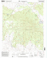
1999 Map of Pitchfork Canyon
USGS Topo · Published 2002About this map
Gila National Forest encompasses this high-altitude landscape in Catron County, where the Continental Divide winds across the ridgelines. The topography is defined by a series of deep drainages, including Pitchfork Canyon and La Jolla Canyon, which fall away from the central mass of Elk Mountain. Human impact in this late-twentieth-century landscape is marked primarily by ranching and forest management infrastructure. A network of water sources, such as Double Barrel Spring and Shantie Spring, alongside numerous stock tanks like Seven HL Tank and West Elk Tank, indicate the ongoing utility of this land for livestock. Transportation is limited to rugged tracks such as the Seven HL Road and the Continental Divide Scenic Trail, which provides a corridor for long-distance travel through the forest.
Find a feature on this map
32 named features on this map. Tap any name to fly to it.
Don’t see what you’re looking for? This feature index may not catch every label — zoom into the map to look around manually.
Map Details
Editions of this 1999 Pitchfork Canyon Map
This is the sole edition of this map. No revisions or reprints were ever made.
Other maps of this area

1910 · Mogollon
USGS Topo · 1:125,000

1911 · Alum Mountain
USGS Topo · 1:125,000

1912 · Mogollon
USGS Topo · 1:125,000

1913 · Alum Mountain
USGS Topo · 1:125,000

1915 · Reserve
USGS Topo · 1:125,000

1918 · Pelona
USGS Topo · 1:125,000

1918 · Reserve
USGS Topo · 1:125,000

1954 · Clifton
USGS Topo · 1:250,000

1957 · Clifton
USGS Topo · 1:250,000

1958 · Clifton
USGS Topo · 1:250,000