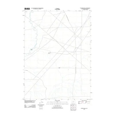
2012 Map of Pittman Well
USGS Topo · Published 2012About this map
The Green River-South Pass Stage Rd cuts through this high desert landscape, tracing a historic transportation corridor across the Wyoming basin. This route, alongside the winding course of the Big Sandy River, defines the topography of a region marked by dry drainages and intermittent watercourses. Several named geographical features characterize the arid terrain, including Starvation Wash, Stagecoach Draw, and Jensen Wash, which channel seasonal runoff toward the river valley. The map documents a sparse network of modern and historical routes, where the long diagonal of the stage road intersects with contemporary paths like Blue Rim Rd. The presence of these named draws and roads underscores the area's history as a transit point for early western travel, where access to water and navigable passes through the basin were critical for survival and commerce.
Find a feature on this map
7 named features on this map. Tap any name to fly to it.
Don’t see what you’re looking for? This feature index may not catch every label — zoom into the map to look around manually.
Map Details
Editions of this 2012 Pittman Well Map
This is the sole edition of this map. No revisions or reprints were ever made.
Other maps of this area

1954 · Rock Springs
USGS Topo · 1:250,000

1955 · Lander
USGS Topo · 1:250,000

1958 · Lander
USGS Topo · 1:250,000

1958 · Rock Springs
USGS Topo · 1:250,000

1961 · Lander
USGS Topo · 1:250,000

1962 · Rock Springs
USGS Topo · 1:250,000

1963 · Gasson Bridge
USGS Topo · 1:24,000

1963 · Pittman Well
USGS Topo · 1:24,000

1963 · Big Island Bridge
USGS Topo · 1:24,000
1963 · Chrisman Ranch
USGS Topo · 1:24,000