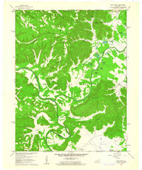
1960 Map of Pitts Point
USGS Topo · Published 1961About this map
Fort Knox Military Reservation dominates the landscape of this 1960 revision, where the Salt River and Rolling Fork converge near the former settlement of Pitts Point. The terrain is defined by dramatic elevation changes, from the alluvial plains of Atherton Flats to the prominent heights of Jeff Lee Ridge and The Knobs. This map serves as a vital record for genealogists, as the expansion of the military reservation preserved numerous small family burial grounds that might otherwise have been lost to development, including Woolridge Cem, Holsclaw Cem, and Troutman Cem. Evidence of earlier river crossings remains at the Floating Bridge Site, while the presence of Hays School and the community of Rising Sun near the northern boundary indicates the persistent rural character of the land outside the artillery ranges and training grounds.
Find a feature on this map
65 named features on this map. Tap any name to fly to it.
Don’t see what you’re looking for? This feature index may not catch every label — zoom into the map to look around manually.
Map Details
Editions of this 1960 Pitts Point Map
3 editions found
Other maps of this area

1907 · Louisville
USGS Topo · 1:62,500

1909 · Kosmosdale
USGS Topo · 1:48,000

1912 · Kosmosdale
USGS Topo · 1:62,500

1936 · Vine Grove
USGS Topo · 1:62,500

1943 · Vine Grove
USGS Topo · 1:62,500

1946 · Pitts Point
USGS Topo · 1:24,000

1946 · Fort Knox
USGS Topo · 1:24,000

1946 · Colesburg
USGS Topo · 1:24,000

1946 · Vine Grove
USGS Topo · 1:24,000

1946 · Vine Grove
USGS Topo · 1:62,500