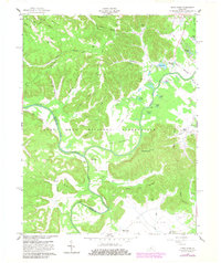
1960 Map of Pitts Point
USGS Topo · Published 1983About this map
The confluence of the Salt River and the Rolling Fork anchors this landscape, where the flatlands of Atherton Flats meet the high ground of Sun Rising Ridge. This area is defined by the massive footprint of the Fort Knox Military Reservation, which encompasses numerous family burial grounds and former homesteads. Genealogists will find a high concentration of small cemeteries scattered throughout the knobs and hollows, including the Shepherd Cem, Rising Sun Cem, and Chappel Cem.
Find a feature on this map
76 named features on this map. Tap any name to fly to it.
Don’t see what you’re looking for? This feature index may not catch every label — zoom into the map to look around manually.
Map Details
Editions of this 1960 Pitts Point Map
3 editions found
Other maps of this area

1907 · Louisville
USGS Topo · 1:62,500

1909 · Kosmosdale
USGS Topo · 1:48,000

1912 · Kosmosdale
USGS Topo · 1:62,500

1936 · Vine Grove
USGS Topo · 1:62,500

1943 · Vine Grove
USGS Topo · 1:62,500

1946 · Pitts Point
USGS Topo · 1:24,000

1946 · Fort Knox
USGS Topo · 1:24,000

1946 · Colesburg
USGS Topo · 1:24,000

1946 · Vine Grove
USGS Topo · 1:24,000

1946 · Vine Grove
USGS Topo · 1:62,500