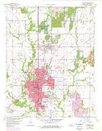
1959 Map of Pittsburg
USGS Topo · Published 1978About this map
Pittsburg anchors this 1950s landscape, revealing a city defined by its educational institutions and intensive industrial history. The presence of Kansas State College of Pittsburg and schools such as Lakeside Sch and Lincoln Sch underscore the town's role as a regional center. Surrounding the urban core, the terrain is heavily marked by extensive Strip Mine operations and tailings, particularly near Frontenac and Yale. The mapping of reclaimed areas highlights the evolving relationship between the local economy and the land.
Find a feature on this map
56 named features on this map. Tap any name to fly to it.
Don’t see what you’re looking for? This feature index may not catch every label — zoom into the map to look around manually.
Map Details
Editions of this 1959 Pittsburg Map
3 editions found
Other maps of this area

1884 · Fort Scott
USGS Topo · 1:125,000

1886 · Joplin
USGS Topo · 1:125,000

1886 · Fort Scott
USGS Topo · 1:125,000

1893 · Fort Scott
USGS Topo · 1:125,000

1894 · Joplin
USGS Topo · 1:125,000

1943 · Cherokee
USGS Topo · 1:62,500

1945 · Pittsburg
USGS Topo · 1:62,500

1945 · Cherokee
USGS Topo · 1:62,500

1947 · Joplin
USGS Topo · 1:250,000

1947 · Pittsburg
USGS Topo · 1:62,500