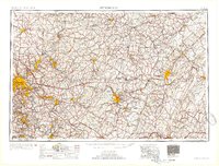
1954 Map of Pittsburgh
USGS Topo · Published 1954About this map
Allegheny Mountains dominate the eastern reaches of this mid-century Pennsylvania landscape, where the Pennsylvania RR and Baltimore and Ohio RR connect industrial centers like McKeesport and Johnstown. This 1954 compilation by the Army Map Service details the post-war transportation network, featuring the prominent route of the Pennsylvania Turnpike as it cuts through the ridges.
Find a feature on this map
91 named features on this map. Tap any name to fly to it.
Don’t see what you’re looking for? This feature index may not catch every label — zoom into the map to look around manually.
Map Details
Editions of this 1954 Pittsburgh Map
2 editions found

Other maps of this area

1900 · Uniontown
USGS Topo · 1:62,500

1900 · Mercersburg
USGS Topo · 1:62,500

1900 · Masontown
USGS Topo · 1:62,500

1900 · Latrobe
USGS Topo · 1:62,500
1900 · Everett
USGS Topo · 1:62,500

1900 · Kittanning
USGS Topo · 1:62,500

1901 · Amity
USGS Topo · 1:62,500

1901 · Rural Valley
USGS Topo · 1:62,500

1901 · Waynesburg
USGS Topo · 1:62,500
1901 · Huntingdon
USGS Topo · 1:62,500