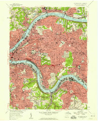
1956 Map of Pittsburgh East
USGS Topo · Published 1959About this map
The Allegheny River and Monongahela River dominate this mid-century portrait of Pittsburgh's eastern landscape, converging toward the city's famous Point. The industrial and academic heart of the region is visible through the sprawling campuses of the University of Pittsburgh and Carnegie Institute of Technology, adjacent to the cultural landmarks of Schenley Park and the Mellon Institute. Extensive rail infrastructure, including the Pennsylvania Railroad and the Baltimore and Ohio Railroad, carves through established neighborhoods like Shadyside and East Liberty, illustrating how the city's growth was dictated by its topography.
Find a feature on this map
115 named features on this map. Tap any name to fly to it.
Don’t see what you’re looking for? This feature index may not catch every label — zoom into the map to look around manually.
Map Details
Editions of this 1956 Pittsburgh East Map
This is the sole edition of this map. No revisions or reprints were ever made.
Other maps of this area

1904 · Mc Keesport
USGS Topo · 1:62,500

1904 · Carnegie
USGS Topo · 1:62,500

1906 · Carnegie
USGS Topo · 1:62,500

1906 · Sewickley
USGS Topo · 1:62,500

1907 · Pittsburg
USGS Topo · 1:62,500

1908 · Sewickley
USGS Topo · 1:62,500

1908 · Carnegie
USGS Topo · 1:62,500

1908 · New Kensington
USGS Topo · 1:62,500

1910 · New Kensington
USGS Topo · 1:62,500

1948 · Pittsburgh West
USGS Topo · 1:24,000