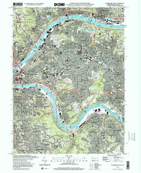
1997 Map of Pittsburgh East
USGS Topo · Published 2000About this map
Schenley Heights and the dense neighborhoods of the East End dominate this late-twentieth-century landscape, capturing the industrial and academic heart of the region. The Allegheny River and Monongahela River frame the city's golden triangle, where massive infrastructure like the Liberty Bridge and Washington Crossing Br connects the central business district to outlying boroughs. Extensive green spaces and institutional grounds provide a counterpoint to the urban grid, notably the sprawling Allegheny Cemetery and the academic corridor featuring Carnegie-Mellon University and the Univ of Pittsburgh with its iconic Cathedral of Learning. The era's urban geography is further defined by historic residential enclaves like Shadyside, Squirrel Hill, and East Liberty, along with landmarks of the period including the Civic Arena and the Lawrence Convention Ctr.
Find a feature on this map
158 named features on this map. Tap any name to fly to it.
Don’t see what you’re looking for? This feature index may not catch every label — zoom into the map to look around manually.
Map Details
Editions of this 1997 Pittsburgh East Map
2 editions found
Other maps of this area

1904 · Mc Keesport
USGS Topo · 1:62,500

1904 · Carnegie
USGS Topo · 1:62,500

1906 · Carnegie
USGS Topo · 1:62,500

1906 · Sewickley
USGS Topo · 1:62,500

1907 · Pittsburg
USGS Topo · 1:62,500

1908 · Sewickley
USGS Topo · 1:62,500

1908 · Carnegie
USGS Topo · 1:62,500

1908 · New Kensington
USGS Topo · 1:62,500

1910 · New Kensington
USGS Topo · 1:62,500

1948 · Pittsburgh West
USGS Topo · 1:24,000