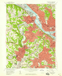
1956 Map of Pittsburgh West
USGS Topo · Published 1959About this map
Industrial corridors and residential expansion define this mid-century landscape where the Ohio River begins at the confluence of the Allegheny River and Monongahela River. The map captures a critical period of infrastructure growth, showing the newly established Point State Park and the network of bridges—including the Fort Pitt Bridge and Fort Duquesne Bridge—that connect the Golden Triangle to the western boroughs. Heavy rail traffic is evident along the riverbanks, with extensive tracks for the Pennsylvania RR and the Pittsburgh and Lake Erie RR serving the industrial heart of McKees Rocks and Esplen.
Find a feature on this map
103 named features on this map. Tap any name to fly to it.
Don’t see what you’re looking for? This feature index may not catch every label — zoom into the map to look around manually.
Map Details
Editions of this 1956 Pittsburgh West Map
This is the sole edition of this map. No revisions or reprints were ever made.
Other maps of this area

1904 · Mc Keesport
USGS Topo · 1:62,500

1904 · Carnegie
USGS Topo · 1:62,500

1906 · Carnegie
USGS Topo · 1:62,500

1906 · Sewickley
USGS Topo · 1:62,500

1907 · Pittsburg
USGS Topo · 1:62,500

1908 · Sewickley
USGS Topo · 1:62,500

1908 · Carnegie
USGS Topo · 1:62,500

1908 · New Kensington
USGS Topo · 1:62,500

1910 · New Kensington
USGS Topo · 1:62,500

1948 · Pittsburgh West
USGS Topo · 1:24,000