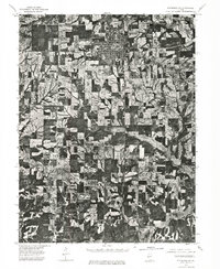
1975 Map of Pittsfield SE
USGS Topo · Published 1976About this map
Pittsfield serves as the primary urban center for this section of Pike County, as captured in this orthophotograph based on an April 1975 aerial survey. The map provides a high-resolution visual record of the late-century agricultural and civic layout, showing the town's dense grid of streets and surrounding homesteads before later developments. Further south, the small community of Martinsburg appears as a distinct rural cluster. The imagery reveals the intricate drainage patterns and woodlots that break up the expansive Midwestern farm fields, offering a clear view of land-use boundaries and property divisions. This specific document is an orthophotoquad, which combines the geographic accuracy of a topographic map with the photographic detail of the actual terrain, making it an essential resource for identifying specific field structures and tree lines as they existed in the mid-1970s.
Find a feature on this map
2 named features on this map. Tap any name to fly to it.
Don’t see what you’re looking for? This feature index may not catch every label — zoom into the map to look around manually.
Map Details
Editions of this 1975 Pittsfield SE Map
This is the sole edition of this map. No revisions or reprints were ever made.
Other maps of this area

1924 · Griggsville
USGS Topo · 1:62,500

1926 · Griggsville
USGS Topo · 1:62,500

1926 · Pittsfield
USGS Topo · 1:62,500

1930 · Pearl
USGS Topo · 1:62,500

1930 · Nebo
USGS Topo · 1:62,500

1934 · Nebo
USGS Topo · 1:48,000

1942 · Nebo
USGS Topo · 1:62,500

1948 · Quincy
USGS Topo · 1:250,000

1950 · Pearl
USGS Topo · 1:62,500

1956 · Quincy
USGS Topo · 1:250,000