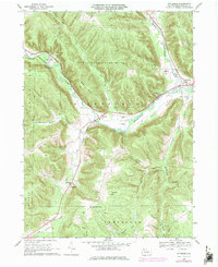
1968 Map of Pittsfield
USGS Topo · Published 1976About this map
Brokenstraw Creek and Little Brokenstraw Creek converge near Pittsfield, anchoring a valley defined by the Penn Central rail line and a series of rural hamlets. This 1968 survey, updated in the mid-1970s, documents the industrial and civic landscape of western Warren County, from the County Fairground north of Pittsfield to the smaller settlements of Garland and Torpedo. The hillsides are largely dominated by State Game Lands No 143, yet the valley floors show active extraction and utility networks, including numerous oil wells, a Quarry, and a high-voltage pipeline. Genealogists may find value in the specific locations of Whitestown Cem, Riverside Cem, and the Community Church near Torpedo. The map also preserves the route of an old railroad grade, illustrating the evolution of transportation through these wooded corridors.
Find a feature on this map
43 named features on this map. Tap any name to fly to it.
Don’t see what you’re looking for? This feature index may not catch every label — zoom into the map to look around manually.
Map Details
Editions of this 1968 Pittsfield Map
Other maps of this area

1926 · Youngsville
USGS Topo · 1:62,500

1927 · Tidioute
USGS Topo · 1:48,000

1927 · Titusville
USGS Topo · 1:62,500

1929 · Corry
USGS Topo · 1:48,000

1929 · Youngsville
USGS Topo · 1:62,500

1930 · Tidioute
USGS Topo · 1:62,500

1932 · Corry
USGS Topo · 1:62,500

1933 · Titusville
USGS Topo · 1:62,500

1943 · Youngsville
USGS Topo · 1:62,500

1957 · Warren
USGS Topo · 1:250,000
Featured Places
- Pittsfield Township, PA
- Spring Creek Township, PA
- Eldred Township, PA
- Deerfield Township, PA
- Torpedo, PA