
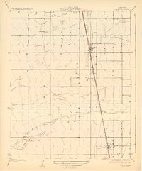
1929 Map of Pixley
USGS Topo · Published 1929About this map
Pixley and Earlimart anchor the agricultural landscape of this Tulare County survey, reflecting a period of steady San Joaquin Valley expansion during the late 1920s. The region is defined by a rigid section-line road grid and the dominant path of the Southern Pacific railroad, which runs nearly north-south through the center of the sheet. This transit corridor was essential for moving local produce and goods, connecting these burgeoning towns to larger California markets. Natural drainage is represented by the winding course of Deer Creek, which meanders across the southern and northern portions of the quadrangle, and the presence of a Slough in the northern section. The map illustrates the early development of irrigation and land division that would eventually transform this arid terrain into one of the most productive farming belts in the state.
Find a feature on this map
7 named features on this map. Tap any name to fly to it.
Don’t see what you’re looking for? This feature index may not catch every label — zoom into the map to look around manually.
Map Details
Editions of this 1929 Pixley Map
2 editions found
Other maps of this area

1925 · Tipton
USGS Topo · 1:31,680

1927 · Lake View School
USGS Topo · 1:31,680

1928 · Tipton
USGS Topo · 1:31,680

1928 · Woodville
USGS Topo · 1:31,680

1929 · Alpaugh
USGS Topo · 1:31,680

1929 · Delano
USGS Topo · 1:31,680

1929 · Sausalito School
USGS Topo · 1:31,680

1929 · Stone
USGS Topo · 1:31,680

1929 · Allensworth
USGS Topo · 1:31,680
1942 · Porterville
USGS Topo · 1:62,500