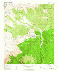
1954 Map of Placitas
USGS Topo · Published 1963About this map
The Sandia Mountains and the Crest of Montezuma dominate this mid-century topographic view of the New Mexico landscape. The settlement of Placitas serves as a central hub, surrounded by a complex network of land grants including the San Antonio de las Huertas Grant and El Ranchito Grant. A legacy of resource extraction is evident through several industrial sites, such as a Coal Mine (Aband) and various Strip Mines scattered near the foothills. The influence of traditional water management is shown by the Algodones Ditch and numerous arroyos like Arroyo del Agua. Evidence of long-term human habitation is noted by Cliff Dwellings tucked into the southern canyons, while the presence of the A T & S F RR and the Fish Hatchery (Inactive) reflect the varied infrastructure and economic shifts occurring in Sandoval County during this era.
Find a feature on this map
60 named features on this map. Tap any name to fly to it.
Don’t see what you’re looking for? This feature index may not catch every label — zoom into the map to look around manually.
Map Details
Editions of this 1954 Placitas Map
4 editions found
Other maps of this area

1888 · Bernalillo
USGS Topo · 1:125,000

1889 · Albuquerque
USGS Topo · 1:125,000

1892 · San Pedro
USGS Topo · 1:125,000

1893 · Albuquerque
USGS Topo · 1:125,000

1934 · Alameda
USGS Topo · 1:24,000

1938 · Albuquerque
USGS Topo · 1:62,500

1954 · Sandia Crest
USGS Topo · 1:24,000

1954 · Alameda
USGS Topo · 1:24,000

1954 · San Felipe Pueblo
USGS Topo · 1:24,000

1954 · Placitas
USGS Topo · 1:24,000