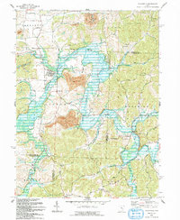
1993 Map of Plainfield
USGS Topo · Published 1993About this map
Wills Creek Lake dominates this landscape in eastern Ohio, where the winding course of Wills Creek snakes through the townships of Linton, Wheeling, and Oxford. This 1993 revision reveals a region defined by its narrow valleys and water-management history, with numerous small settlements like Linton Mills and Plainfield established along the drainage. The map provides significant genealogical value through its several rural burial grounds, including Schweitzer Cem, Union Hill Cem, and Valley Cem. Industrial and infrastructure development is clearly visible in the form of multiple Strip Mine operations and a major Pipeline corridor that cuts across the northern ridges. Small aviation history is represented by the Tri-City Airport near the northern boundary, while rural landmarks such as Lawyers Corners and Cooks Corner mark local crossroads in a landscape heavily influenced by the reservoir's flood control basin.
Find a feature on this map
50 named features on this map. Tap any name to fly to it.
Don’t see what you’re looking for? This feature index may not catch every label — zoom into the map to look around manually.
Map Details
Editions of this 1993 Plainfield Map
This is the sole edition of this map. No revisions or reprints were ever made.
Other maps of this area

1908 · Conesville
USGS Topo · 1:62,500

1909 · Cambridge
USGS Topo · 1:62,500

1910 · Conesville
USGS Topo · 1:62,500

1911 · Newcomerstown
USGS Topo · 1:62,500

1912 · Cambridge
USGS Topo · 1:62,500

1913 · Newcomerstown
USGS Topo · 1:62,500

1913 · Coshocton
USGS Topo · 1:62,500

1915 · Coshocton
USGS Topo · 1:62,500

1943 · Coshocton
USGS Topo · 1:62,500

1943 · Newcomerstown
USGS Topo · 1:62,500