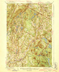
1943 Map of Plainfield
USGS Topo · Published 1943About this map
The Winooski River and the Montpelier and Wells River RR corridor anchor this rural landscape in central Vermont, illustrating a mid-century pattern of small village centers and high-altitude hill farms. The survey identifies a dense network of local landmarks, including the landmark Old West Ch and numerous district schools like the Pekin Sch and Hollister Hill Sch, which served the scattered farming communities of Calais and Marshfield.
Find a feature on this map
107 named features on this map. Tap any name to fly to it.
Don’t see what you’re looking for? This feature index may not catch every label — zoom into the map to look around manually.
Map Details
Editions of this 1943 Plainfield Map
2 editions found

Other maps of this area

1919 · Montpelier
USGS Topo · 1:62,500

1921 · Montpelier
USGS Topo · 1:62,500

1922 · Barre
USGS Topo · 1:48,000

1924 · Barre
USGS Topo · 1:62,500

1927 · Hyde Park
USGS Topo · 1:48,000

1928 · Hardwick
USGS Topo · 1:62,500

1930 · Hyde Park
USGS Topo · 1:62,500

1931 · Woodsville
USGS Topo · 1:48,000

1934 · Hardwick
USGS Topo · 1:48,000

1935 · Woodsville
USGS Topo · 1:62,500