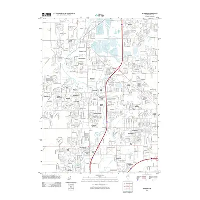
2012 Map of Plainfield
USGS Topo · Published 2012About this map
The Du Page River corridor defines the landscape of this region, providing a natural artery through a rapidly expanding network of residential developments and historic sites. Major water bodies like Lake Renwick and Lake Plainfield punctuate the terrain, while the extensive reach of Lily Cache and its tributaries such as Lily Cache Cr crisscross the northern sections. This 2012 documentation illustrates the dense clustering of neighborhoods such as Crystal Lawns, Wesmere, and Arbor Creek, which represent the transition from agrarian roots to suburban density.
Find a feature on this map
88 named features on this map. Tap any name to fly to it.
Don’t see what you’re looking for? This feature index may not catch every label — zoom into the map to look around manually.
Map Details
Editions of this 2012 Plainfield Map
This is the sole edition of this map. No revisions or reprints were ever made.
Other maps of this area

1892 · Morris
USGS Topo · 1:62,500

1892 · Joliet
USGS Topo · 1:62,500

1892 · Wilmington
USGS Topo · 1:62,500

1918 · Wilmington
USGS Topo · 1:62,500

1918 · Morris
USGS Topo · 1:62,500

1923 · Joliet
USGS Topo · 1:62,500

1925 · Yorkville
USGS Topo · 1:62,500

1953 · Yorkville SE
USGS Topo · 1:24,000
1953 · Normantown
USGS Topo · 1:24,000
1953 · Elwood
USGS Topo · 1:24,000