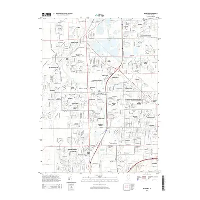
2015 Map of Plainfield
USGS Topo · Published 2015About this map
The DuPage River corridor and its surrounding residential expansions define this part of Will County, showcasing the dense suburban transformation of the early 21st century. While Plainfield and Romeoville represent major hubs, the landscape is a patchwork of named subdivisions and planned communities such as Arbor Settlement, Wesglen, and Lakewood Falls. These developments are interwoven with natural and managed water features, including Lake Renwick and the winding Lily Cache Creek. For those tracing local heritage, several burial grounds are preserved amidst the growth, including the Plainfield Cemetery and the County Farm Cem. The map also highlights significant regional infrastructure, notably the Joliet Regional Airport and the southern reaches of the Illinois and Michigan Canal National Heritage Corridor, marking the area's transition from an agricultural past to a modern logistics and residential center.
Find a feature on this map
88 named features on this map. Tap any name to fly to it.
Don’t see what you’re looking for? This feature index may not catch every label — zoom into the map to look around manually.
Map Details
Editions of this 2015 Plainfield Map
This is the sole edition of this map. No revisions or reprints were ever made.
Other maps of this area

1892 · Morris
USGS Topo · 1:62,500

1892 · Joliet
USGS Topo · 1:62,500

1892 · Wilmington
USGS Topo · 1:62,500

1918 · Wilmington
USGS Topo · 1:62,500

1918 · Morris
USGS Topo · 1:62,500

1923 · Joliet
USGS Topo · 1:62,500

1925 · Yorkville
USGS Topo · 1:62,500

1953 · Yorkville SE
USGS Topo · 1:24,000
1953 · Normantown
USGS Topo · 1:24,000
1953 · Elwood
USGS Topo · 1:24,000