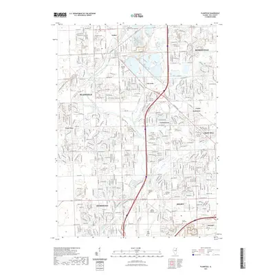
2021 Map of Plainfield
USGS Topo · Published 2021About this map
Plainfield and its surrounding suburban landscape are defined by the winding course of the DuPage River, which anchors several historic communities in Will County. This modern survey illustrates the dense residential expansion radiating from the commercial corridors of Joliet and Shorewood. In the northern half of the map, the small settlement of Lily Cache and the Plainfield Township Cem reflect the area's agricultural and local-history roots, while the presence of the Joliet Regional Airport and Joliet Junior College highlights the region's development as a major infrastructure hub.
Find a feature on this map
55 named features on this map. Tap any name to fly to it.
Don’t see what you’re looking for? This feature index may not catch every label — zoom into the map to look around manually.
Map Details
Editions of this 2021 Plainfield Map
This is the sole edition of this map. No revisions or reprints were ever made.
Other maps of this area

1892 · Morris
USGS Topo · 1:62,500

1892 · Joliet
USGS Topo · 1:62,500

1892 · Wilmington
USGS Topo · 1:62,500

1918 · Wilmington
USGS Topo · 1:62,500

1918 · Morris
USGS Topo · 1:62,500

1923 · Joliet
USGS Topo · 1:62,500

1925 · Yorkville
USGS Topo · 1:62,500

1953 · Yorkville SE
USGS Topo · 1:24,000
1953 · Normantown
USGS Topo · 1:24,000
1953 · Elwood
USGS Topo · 1:24,000