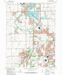
1993 Map of Plainfield
USGS Topo · Published 1994About this map
Plainfield and the neighboring communities of Shorewood and Troy sit at a geographic crossroads where the Du Page River and Lake Renwick define the local topography. This 1993 edition, updated from mid-century photogrammetry, reveals a suburban landscape in transition, characterized by established institutions like the Servant of Mary Convent and multiple cemeteries including Plainfield Cemetery and St Marys Cem.
Find a feature on this map
83 named features on this map. Tap any name to fly to it.
Don’t see what you’re looking for? This feature index may not catch every label — zoom into the map to look around manually.
Map Details
Editions of this 1993 Plainfield Map
This is the sole edition of this map. No revisions or reprints were ever made.
Other maps of this area

1892 · Morris
USGS Topo · 1:62,500

1892 · Joliet
USGS Topo · 1:62,500

1892 · Wilmington
USGS Topo · 1:62,500

1918 · Wilmington
USGS Topo · 1:62,500

1918 · Morris
USGS Topo · 1:62,500

1923 · Joliet
USGS Topo · 1:62,500

1925 · Yorkville
USGS Topo · 1:62,500

1953 · Yorkville SE
USGS Topo · 1:24,000
1953 · Normantown
USGS Topo · 1:24,000
1953 · Elwood
USGS Topo · 1:24,000