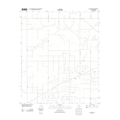
2012 Map of Plains NW
USGS Topo · Published 2012About this map
The Brahaney Oil Field dominates this sector of Yoakum County, illustrating the heavy industrial footprint of petroleum extraction in the West Texas landscape. A rigid grid of section lines and access roads defines the area, reflecting the systematic land survey and resource management typical of the High Plains. Long-established transportation routes such as Old Lovington Rd and Whiskey Rd cut across the landscape, connecting this remote industrial zone to regional hubs. Family-named roads, including Johnnie Layton Rd, Randall Freeman Rd, and Patton Rd, offer valuable clues for genealogists tracking local land ownership and the placement of rural homesteads. The concentration of tank batteries and well sites near Chambliss Rd and Ranch Road 1622 underscores the intensive energy production that has long sustained the local economy.
Find a feature on this map
21 named features on this map. Tap any name to fly to it.
Don’t see what you’re looking for? This feature index may not catch every label — zoom into the map to look around manually.
Map Details
Editions of this 2012 Plains NW Map
This is the sole edition of this map. No revisions or reprints were ever made.
Other maps of this area

1954 · Brownfield
USGS Topo · 1:250,000

1958 · Brownfield
USGS Topo · 1:250,000

1962 · Brownfield
USGS Topo · 1:250,000

1970 · Prairieview NE
USGS Topo · 1:24,000

1970 · Bronco
USGS Topo · 1:24,000

1970 · Prairieview SE
USGS Topo · 1:24,000

1971 · Plains NW
USGS Topo · 1:24,000
1971 · Ink Basin
USGS Topo · 1:24,000
1971 · Plains SE
USGS Topo · 1:24,000
1971 · Plains
USGS Topo · 1:24,000