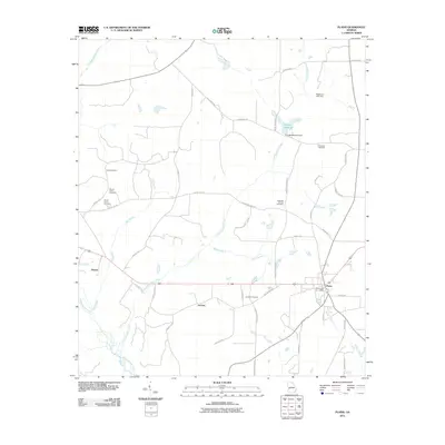
2011 Map of Plains
USGS Topo · Published 2011About this map
Plains serves as the primary hub in this West Georgia landscape, situated along the crossroads of Highway 280. The rural character of the region is defined by a dense network of family-named roads and agrarian settlements like Archery and Dumas. Waterways such as Choctahatchee Creek and Kinchafoonee Creek drain the terrain, with agricultural heritage evidenced by Youngs Millpond and its associated dam. Genealogists will find significant value in the distribution of local burial sites, including Davis Cemetery, Mount Avery Cemetery, and Tabernacle Cemetery. The map also identifies the Plains Post Office, a central landmark for this community. The road system, from Old Plains Hwy to Oscar Williams Rd, illustrates the persistent connectivity between dispersed homesteads and the town center in the early 21st century.
Find a feature on this map
47 named features on this map. Tap any name to fly to it.
Don’t see what you’re looking for? This feature index may not catch every label — zoom into the map to look around manually.
Map Details
Editions of this 2011 Plains Map
This is the sole edition of this map. No revisions or reprints were ever made.
Other maps of this area

1953 · Dothan
USGS Topo · 1:250,000

1954 · Dothan
USGS Topo · 1:250,000

1955 · Dothan
USGS Topo · 1:250,000

1955 · Phenix City
USGS Topo · 1:250,000

1957 · Phenix City
USGS Topo · 1:250,000

1958 · Phenix City
USGS Topo · 1:250,000
1972 · Preston
USGS Topo · 1:24,000

1972 · Parrott
USGS Topo · 1:24,000

1972 · Ellaville South
USGS Topo · 1:24,000
1973 · Church Hill
USGS Topo · 1:24,000