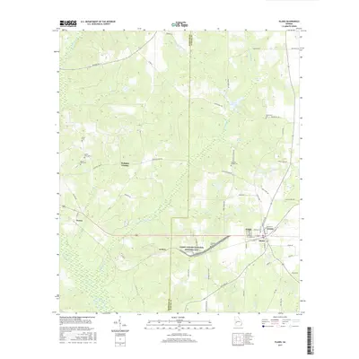
2017 Map of Plains
USGS Topo · Published 2017About this map
The Jimmy Carter National Historic Site anchors the southern half of this landscape, encompassing areas near the settlements of Plains and Archery. This region on the border of Webster County and Sumter County is characterized by a series of north-south flowing watercourses, including Kinchafoonee Cr and Choctahatchee Cr, which drain the agricultural land between rising ridges. Local history is deeply etched into the terrain through numerous family and community burial grounds, such as Mount Avery Cem and Lebanon Cem. While the town of Plains shows a concentrated street grid around W Main St and Hospital St, the surrounding countryside is defined by landmarks like Magnolia Spring and Youngs Millpond, reflecting a rural economy tied closely to the land's hydrology and the legacies of the families who settled here.
Find a feature on this map
62 named features on this map. Tap any name to fly to it.
Don’t see what you’re looking for? This feature index may not catch every label — zoom into the map to look around manually.
Map Details
Editions of this 2017 Plains Map
This is the sole edition of this map. No revisions or reprints were ever made.
Other maps of this area

1953 · Dothan
USGS Topo · 1:250,000

1954 · Dothan
USGS Topo · 1:250,000

1955 · Dothan
USGS Topo · 1:250,000

1955 · Phenix City
USGS Topo · 1:250,000

1957 · Phenix City
USGS Topo · 1:250,000

1958 · Phenix City
USGS Topo · 1:250,000
1972 · Preston
USGS Topo · 1:24,000

1972 · Parrott
USGS Topo · 1:24,000

1972 · Ellaville South
USGS Topo · 1:24,000
1973 · Church Hill
USGS Topo · 1:24,000