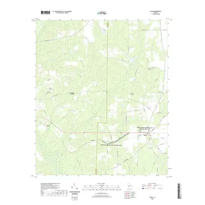
2020 Map of Plains
USGS Topo · Published 2020About this map
Plains and the surrounding farmland of Webster County and Sumter County are documented here in detail, centering on the hometown of the 39th President. The landscape is defined by the Jimmy Carter National Historic Site, which preserves the rural environment and agricultural heritage of the area, including the settlement of Archery. This region is characterized by a network of creeks and branches, such as Choctahatchee Cr and Kinchafoonee Cr, which drain the rolling terrain. Numerous small family and community burial grounds are scattered throughout the countryside, including Mount Avery Cem, Davis Cem, and Tabernacle Cem. Local infrastructure like Old Plains Hwy and several named roads connect the outlying communities of Dumas and Archery to the central hub at Plains, illustrating the enduring layout of this South Georgia farming district.
Find a feature on this map
57 named features on this map. Tap any name to fly to it.
Don’t see what you’re looking for? This feature index may not catch every label — zoom into the map to look around manually.
Map Details
Editions of this 2020 Plains Map
This is the sole edition of this map. No revisions or reprints were ever made.
Other maps of this area

1953 · Dothan
USGS Topo · 1:250,000

1954 · Dothan
USGS Topo · 1:250,000

1955 · Dothan
USGS Topo · 1:250,000

1955 · Phenix City
USGS Topo · 1:250,000

1957 · Phenix City
USGS Topo · 1:250,000

1958 · Phenix City
USGS Topo · 1:250,000
1972 · Preston
USGS Topo · 1:24,000

1972 · Parrott
USGS Topo · 1:24,000

1972 · Ellaville South
USGS Topo · 1:24,000
1973 · Church Hill
USGS Topo · 1:24,000