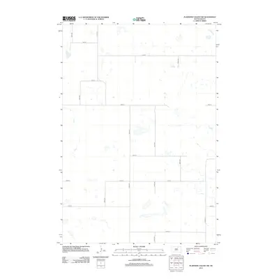
2012 Map of Plainview Colony SW
USGS Topo · Published 2012About this map
McPherson County, South Dakota, is characterized here by its vast, marshy prairie landscape, dominated by numerous unnamed small wetlands and prairie potholes. The land is organized into a rigid section-line grid typical of the Great Plains, where unpaved rural routes like 122nd St and 348th Ave provide the primary infrastructure for agricultural access. This high-resolution survey from the U.S. Geological Survey captures the region's complex hydrography, showing how water gathers in depressions across the high plains. The absence of concentrated settlements or named towns highlights the sparse, purely agricultural nature of this part of the state, where farmstead locations are indicated by small symbols along corridors such as 350th Ave and 128th St. Researchers and genealogists can use this grid to pinpoint specific land parcels and historical property boundaries in this remote corner of the Dakotas.
Find a feature on this map
14 named features on this map. Tap any name to fly to it.
Don’t see what you’re looking for? This feature index may not catch every label — zoom into the map to look around manually.
Map Details
Editions of this 2012 Plainview Colony SW Map
This is the sole edition of this map. No revisions or reprints were ever made.
Other maps of this area

1954 · Aberdeen
USGS Topo · 1:250,000

1956 · Aberdeen
USGS Topo · 1:250,000

1974 · Roscoe
USGS Topo · 1:24,000

1978 · Beebe
USGS Topo · 1:24,000
1978 · Ipswich
USGS Topo · 1:24,000

1978 · Hosmer NE
USGS Topo · 1:24,000

1978 · Hosmer SE
USGS Topo · 1:24,000
1978 · Plainview Colony
USGS Topo · 1:24,000
1978 · Plainview Colony NE
USGS Topo · 1:24,000

1978 · Plainview Colony NW
USGS Topo · 1:24,000