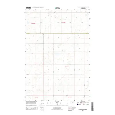
2015 Map of Plainview Colony SW
USGS Topo · Published 2015About this map
The McPherson Co Edmunds Co boundary line divides this agricultural landscape, where the prairie is etched by a rigid section-line road grid typical of the Great Plains. Established thoroughfares like CR-13 and 124th St connect the scattered homesteads and farming operations that define the region's rural economy. The terrain is characterized by numerous small, seasonal prairie potholes and depressions, which influence the winding paths of secondary roads such as 349th Ave and 350th Ave. This topographic study by the U.S. Geological Survey details the fine elevation changes across the open fields, from the northern reaches of 122nd St to the southern extent near 130th St.
Find a feature on this map
23 named features on this map. Tap any name to fly to it.
Don’t see what you’re looking for? This feature index may not catch every label — zoom into the map to look around manually.
Map Details
Editions of this 2015 Plainview Colony SW Map
This is the sole edition of this map. No revisions or reprints were ever made.
Other maps of this area

1954 · Aberdeen
USGS Topo · 1:250,000

1956 · Aberdeen
USGS Topo · 1:250,000

1974 · Roscoe
USGS Topo · 1:24,000

1978 · Beebe
USGS Topo · 1:24,000
1978 · Ipswich
USGS Topo · 1:24,000

1978 · Hosmer NE
USGS Topo · 1:24,000

1978 · Hosmer SE
USGS Topo · 1:24,000
1978 · Plainview Colony
USGS Topo · 1:24,000
1978 · Plainview Colony NE
USGS Topo · 1:24,000

1978 · Plainview Colony NW
USGS Topo · 1:24,000