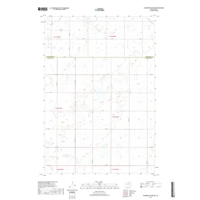
2017 Map of Plainview Colony SW
USGS Topo · Published 2017About this map
The McPherson Co Edmunds Co line defines this portion of the northern plains, where a rigid grid of gravel roads segments the prairie into precise sections. This 2017 survey shows a landscape dominated by hundreds of small prairie potholes and seasonal wetlands, creating a complex hydrologic network across the agricultural flats. Primary transport is dictated by the section-line roads, including 122nd St, 124th St, and Ed Co 14. The map provides a detailed view of the Public Land Survey System (PLSS) divisions across townships like t124n r70w and t125n r69w. While formal settlements are absent from this specific quadrangle, the dense concentration of wetlands and the intersection of county boundaries offer insight into the region's land use and environmental character.
Find a feature on this map
17 named features on this map. Tap any name to fly to it.
Don’t see what you’re looking for? This feature index may not catch every label — zoom into the map to look around manually.
Map Details
Editions of this 2017 Plainview Colony SW Map
This is the sole edition of this map. No revisions or reprints were ever made.
Other maps of this area

1954 · Aberdeen
USGS Topo · 1:250,000

1956 · Aberdeen
USGS Topo · 1:250,000

1974 · Roscoe
USGS Topo · 1:24,000

1978 · Beebe
USGS Topo · 1:24,000
1978 · Ipswich
USGS Topo · 1:24,000

1978 · Hosmer NE
USGS Topo · 1:24,000

1978 · Hosmer SE
USGS Topo · 1:24,000
1978 · Plainview Colony
USGS Topo · 1:24,000
1978 · Plainview Colony NE
USGS Topo · 1:24,000

1978 · Plainview Colony NW
USGS Topo · 1:24,000