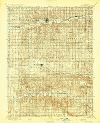
1896 Map of Plainville
USGS Topo · Published 1925About this map
The South Solomon River and the Saline River define the horizontal movement of this late 19th-century central Kansas landscape. The settlement of Stockton sits at a strategic bend where the South Fork Solomon River joins the main branch, served by the Missouri Pacific railroad. Further south, the town of Plainville anchors a high plateau between river systems, positioned along the Union Pacific line.
Find a feature on this map
53 named features on this map. Tap any name to fly to it.
Don’t see what you’re looking for? This feature index may not catch every label — zoom into the map to look around manually.
Map Details
Editions of this 1896 Plainville Map
3 editions found
Other maps of this area

1893 · Ellis
USGS Topo · 1:125,000

1893 · Smith Center
USGS Topo · 1:125,000

1893 · Norton
USGS Topo · 1:125,000

1893 · Phillipsburg
USGS Topo · 1:125,000

1893 · Hill
USGS Topo · 1:125,000

1896 · Osborne
USGS Topo · 1:125,000

1896 · Russell
USGS Topo · 1:125,000

1896 · Hays
USGS Topo · 1:125,000

1896 · Plainville
USGS Topo · 1:125,000

1952 · Webster Dam
USGS Topo · 1:24,000