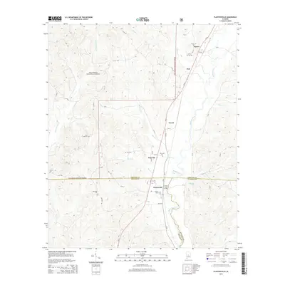
2014 Map of Plantersville
USGS Topo · Published 2014About this map
Mulberry Creek winds through the borderlands of Chilton, Dallas, and Autauga counties, defining the character of this central Alabama landscape in 2014. The terrain is a mixture of the Talladega National Forest in the west and established farming and timber tracts to the east. Small communities like Plantersville, Riderville, and Stanton remain anchored by historical landmarks and crossroads. For the local historian, the map preserves a significant network of family and community burial sites, including Plantersville Cem, Harris Cem, and Oak Grove Cem. The geography is further defined by its numerous watercourses such as Martin Cr and Little Oakmulgee Cr, which dictated early settlement patterns and the placement of infrastructure like the Corley Jones Bridge. This document serves as a detailed record of land use and property boundaries in a rural corridor shaped by the Al-22 highway.
Find a feature on this map
64 named features on this map. Tap any name to fly to it.
Don’t see what you’re looking for? This feature index may not catch every label — zoom into the map to look around manually.
Map Details
Editions of this 2014 Plantersville Map
This is the sole edition of this map. No revisions or reprints were ever made.
Other maps of this area

1891 · Clanton
USGS Topo · 1:125,000

1953 · Montgomery
USGS Topo · 1:250,000

1956 · Montgomery
USGS Topo · 1:250,000

1957 · Montgomery
USGS Topo · 1:250,000

1959 · Plantersville
USGS Topo · 1:62,500

1959 · Summerfield
USGS Topo · 1:62,500
1971 · Maplesville East
USGS Topo · 1:24,000

1971 · Maplesville West
USGS Topo · 1:24,000

1975 · Plantersville SE
USGS Topo · 1:24,000
1975 · Plantersville SW
USGS Topo · 1:24,000