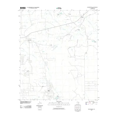
2010 Map of Plantersville
USGS Topo · Published 2010About this map
Todd Mission and Plantersville anchor this map of southeastern Grimes County, showing a landscape defined by small settlements and winding creek beds. The area is characterized by a high density of named cemeteries, including Rose Hill Cemetery, Shannon Cemetery, and Griffith Cemetery, which provide valuable location data for genealogists tracing local families. The terrain is crisscrossed by several waterways such as Mill Creek, Caney Creek, and Kickapoo Creek, along with local landmarks like Lake Hollyhill and Sneed Lake. The road network connects older hubs like Bobville and Dobbin via routes such as Mount Mariah Road and Old Highway 105 West. This 2010 survey reflects a period of rural residential growth, with many private roads and subdivisions like Country Oaks appearing alongside established landmarks and family-named roads.
Find a feature on this map
39 named features on this map. Tap any name to fly to it.
Don’t see what you’re looking for? This feature index may not catch every label — zoom into the map to look around manually.
Map Details
Editions of this 2010 Plantersville Map
This is the sole edition of this map. No revisions or reprints were ever made.
Other maps of this area

1954 · Beaumont
USGS Topo · 1:250,000

1957 · Beaumont
USGS Topo · 1:250,000

1959 · Montgomery
USGS Topo · 1:24,000

1960 · Waller NW
USGS Topo · 1:24,000

1961 · Anderson
USGS Topo · 1:24,000

1961 · Stoneham
USGS Topo · 1:24,000

1962 · Keenan
USGS Topo · 1:24,000

1962 · Dacus
USGS Topo · 1:24,000

1962 · Plantersville
USGS Topo · 1:24,000
1962 · Magnolia East
USGS Topo · 1:24,000