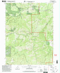
1998 Map of Platina
USGS Topo · Published 2003About this map
Harrison Gulch and the surrounding canyon country dominate this landscape at the intersection of Shasta, Tehama, and Trinity counties. The mining heritage of the region is evident through sites like the Chrome Mine and Sunshine Mine, alongside numerous prospects and a quarry scattered across the ridgelines. Near the small settlement of Platina, the Yolla Bolla Cem stands as a local landmark, while the Sewage Disposal Pond reflects mid-century infrastructure. The terrain is deeply carved by water, with Cottonwood Creek and Beegum Creek cutting through steep topography defined by Noble Ridge and Sugarloaf Mtn. Within the Shasta-Trinity National Forests, developed recreation areas like Basin Gulch Campground and Beegum Gorge Campground highlight the area's use for outdoor forestry and conservation during the late 1990s.
Find a feature on this map
52 named features on this map. Tap any name to fly to it.
Don’t see what you’re looking for? This feature index may not catch every label — zoom into the map to look around manually.
Map Details
Editions of this 1998 Platina Map
This is the sole edition of this map. No revisions or reprints were ever made.
Other maps of this area

1890 · Red Bluff
USGS Topo · 1:250,000

1894 · Red Bluff
USGS Topo · 1:250,000

1931 · Hoaglin
USGS Topo · 1:96,000

1935 · Hoaglin
USGS Topo · 1:125,000

1951 · Chanchelulla Peak
USGS Topo · 1:62,500

1953 · Blackrock Mtn
USGS Topo · 1:62,500

1954 · Dubakella Mtn
USGS Topo · 1:62,500

1954 · Blackrock Mtn
USGS Topo · 1:62,500

1954 · Yolla Bolly
USGS Topo · 1:62,500

1958 · Redding
USGS Topo · 1:250,000