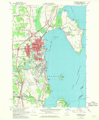
1966 Map of Plattsburgh
USGS Topo · Published 1968About this map
The sprawling Plattsburgh Air Force Base dominates the southern landscape of this mid-1960s survey, illustrating the significant Cold War military footprint on the shores of Lake Champlain. The city of Plattsburgh itself is a dense hub of activity, featuring the State University College and the main line of the Delaware and Hudson railroad. The map captures a transitional era for local infrastructure, as the Adirondack Northway and its numerous interchanges, such as Interchange 38, bypass the traditional downtown corridors like Cornelia St and Macomb St.
Find a feature on this map
96 named features on this map. Tap any name to fly to it.
Don’t see what you’re looking for? This feature index may not catch every label — zoom into the map to look around manually.
Map Details
Editions of this 1966 Plattsburgh Map
2 editions found
Other maps of this area

1894 · Plattsburg
USGS Topo · 1:62,500

1895 · Mooers
USGS Topo · 1:62,500

1895 · Rouse Point
USGS Topo · 1:62,500

1899 · Mooers
USGS Topo · 1:62,500

1906 · Plattsburg
USGS Topo · 1:62,500

1907 · Rouse Point
USGS Topo · 1:62,500

1913 · Dannemora
USGS Topo · 1:62,500

1939 · Rouses Point
USGS Topo · 1:62,500

1939 · Plattsburg
USGS Topo · 1:62,500

1941 · Plattsburg
USGS Topo · 1:62,500