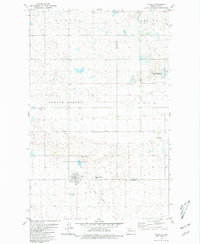
1980 Map of Plaza
USGS Topo · Published 1981About this map
Plaza stands as the central hub of this prairie landscape at the junction of the Soo Line railroad, surrounded by a series of distinct townships and land features including Osloe, Shealey, Lund, and Spring Coulee. The map reveals a community deeply rooted in its local institutions, evidenced by the cluster of cemeteries such as Sacred Heart Cem and First Lutheran Cem. The topography is defined by the prairie pothole region's characteristic wetlands, highlighted by the National Waterfowl Production Area in the northeast. The presence of multiple Gravel Pits and the Soo Line rail corridor suggest a local economy tied to both resource extraction and the transport of agricultural goods from the Mountrail and Ward county line.
Find a feature on this map
17 named features on this map. Tap any name to fly to it.
Don’t see what you’re looking for? This feature index may not catch every label — zoom into the map to look around manually.
Map Details
Editions of this 1980 Plaza Map
This is the sole edition of this map. No revisions or reprints were ever made.
Other maps of this area

1953 · Williston
USGS Topo · 1:250,000

1953 · Watford City
USGS Topo · 1:250,000

1954 · Minot
USGS Topo · 1:250,000

1954 · McClusky
USGS Topo · 1:250,000

1957 · Williston
USGS Topo · 1:250,000

1957 · Watford City
USGS Topo · 1:250,000

1958 · McClusky
USGS Topo · 1:250,000

1958 · Minot
USGS Topo · 1:250,000

1967 · Watford City
USGS Topo · 1:250,000

1980 · Minot
USGS Topo · 1:100,000