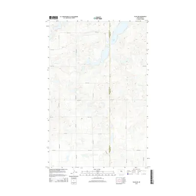
2014 Map of Plaza NW
USGS Topo · Published 2014About this map
Carpenter Lake dominates the northern landscape of this prairie region, sitting just east of the boundary between Mountrail County and Ward County. The terrain is defined by the characteristic pothole topography of the northern plains, where numerous small depressions and seasonal water bodies dot the section lines. A precise grid of rural roads, including 57th St NW and 50th St NW, provides access to the agricultural tracts. This 2014 survey documents the transition between these two counties, showing a landscape of scattered wetlands and farm roads such as 63rd Ave NW and 93rd Ave Sw that maintain the region's long-established township-and-range surveying pattern.
Find a feature on this map
20 named features on this map. Tap any name to fly to it.
Don’t see what you’re looking for? This feature index may not catch every label — zoom into the map to look around manually.
Map Details
Editions of this 2014 Plaza NW Map
This is the sole edition of this map. No revisions or reprints were ever made.
Other maps of this area

1953 · Williston
USGS Topo · 1:250,000

1954 · Minot
USGS Topo · 1:250,000

1957 · Williston
USGS Topo · 1:250,000

1958 · Minot
USGS Topo · 1:250,000

1980 · Minot
USGS Topo · 1:100,000

1980 · Plaza SE
USGS Topo · 1:24,000

1980 · Tagus SE
USGS Topo · 1:24,000
1980 · Plaza
USGS Topo · 1:24,000

1980 · Tagus
USGS Topo · 1:24,000
1980 · Plaza NE
USGS Topo · 1:24,000