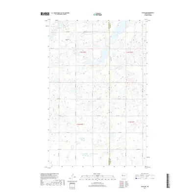
2017 Map of Plaza NW
USGS Topo · Published 2017About this map
Rolling Prairie Cem sits on the high ground of the Missouri Coteau, overlooking a glaciated landscape defined by numerous prairie potholes and wetlands. This 2017 survey captures the rural boundary where Mountrail County and Ward County meet in central North Dakota. The terrain is characterized by its internal drainage, most notably seen at Carpenter Lake in the northeastern corner, which acts as a collection point for the surrounding hills. A regular grid of section roads, including 57th St NW and 408th St NW, segments the prairie, reflecting the enduring legacy of the Public Land Survey System in this agricultural region. The map preserves the exact placement of township lines like t155n r88w and t155n r87w, which remain fundamental to local land ownership and genealogy in these prairie communities.
Find a feature on this map
26 named features on this map. Tap any name to fly to it.
Don’t see what you’re looking for? This feature index may not catch every label — zoom into the map to look around manually.
Map Details
Editions of this 2017 Plaza NW Map
This is the sole edition of this map. No revisions or reprints were ever made.
Other maps of this area

1953 · Williston
USGS Topo · 1:250,000

1954 · Minot
USGS Topo · 1:250,000

1957 · Williston
USGS Topo · 1:250,000

1958 · Minot
USGS Topo · 1:250,000

1980 · Minot
USGS Topo · 1:100,000

1980 · Plaza SE
USGS Topo · 1:24,000

1980 · Tagus SE
USGS Topo · 1:24,000
1980 · Plaza
USGS Topo · 1:24,000

1980 · Tagus
USGS Topo · 1:24,000
1980 · Plaza NE
USGS Topo · 1:24,000