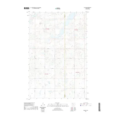
2020 Map of Plaza NW
USGS Topo · Published 2020About this map
Rolling Prairie Cem stands as a lonely landmark in the northwestern corner of this landscape, a site of significant genealogical interest for families of the North Dakota plains. The terrain is defined by the prairie pothole region's characteristic geology, where countless small wetlands and depressions punctuate the high plains of Ward County and Mountrail County. The most prominent water feature, Carpenter Lake, sits in the northern reaches, surrounded by a sparse network of section-line roads such as 57th St NW and 63rd Ave NW. This survey reflects a modern agricultural era where the grid of the Public Land Survey System remains the primary structure for movement and land management. The absence of concentrated towns emphasizes the rural, dispersed nature of this portion of the state, where history is traced through small burial grounds and the natural shifts of seasonal water bodies.
Find a feature on this map
20 named features on this map. Tap any name to fly to it.
Don’t see what you’re looking for? This feature index may not catch every label — zoom into the map to look around manually.
Map Details
Editions of this 2020 Plaza NW Map
This is the sole edition of this map. No revisions or reprints were ever made.
Other maps of this area

1953 · Williston
USGS Topo · 1:250,000

1954 · Minot
USGS Topo · 1:250,000

1957 · Williston
USGS Topo · 1:250,000

1958 · Minot
USGS Topo · 1:250,000

1980 · Minot
USGS Topo · 1:100,000

1980 · Plaza SE
USGS Topo · 1:24,000

1980 · Tagus SE
USGS Topo · 1:24,000
1980 · Plaza
USGS Topo · 1:24,000

1980 · Tagus
USGS Topo · 1:24,000
1980 · Plaza NE
USGS Topo · 1:24,000