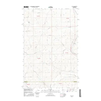
2017 Map of Plaza
USGS Topo · Published 2017About this map
Plaza serves as the primary settlement on this landscape where the borders of Spokane and Whitman counties meet. The terrain is defined by a series of drainages, including Buckeye Cr, John Paulson Cr, and Pine Cr, which cut through the agricultural plateaus of the Palouse region. The local transportation network reveals a deep history of land division and homesteading, with numerous roads bearing family names such as W Mc Dowel Rd, S McDowell Rd, and S Patterson Rd. The map also captures the evolution of regional travel, documenting the alignment of S Old St Route 195 and S Old Highway 195 as they pass through the community of Plaza. The Wells Road Bridge provides a specific point of infrastructure over Sanders Cr, marking a vital crossing in this rural grain-growing district.
Find a feature on this map
43 named features on this map. Tap any name to fly to it.
Don’t see what you’re looking for? This feature index may not catch every label — zoom into the map to look around manually.
Map Details
Editions of this 2017 Plaza Map
This is the sole edition of this map. No revisions or reprints were ever made.
Other maps of this area

1903 · Oakesdale
USGS Topo · 1:125,000

1905 · Oakesdale
USGS Topo · 1:125,000

1954 · Cheney
USGS Topo · 1:62,500

1954 · Spangle
USGS Topo · 1:62,500

1955 · Spokane
USGS Topo · 1:250,000

1958 · Spokane
USGS Topo · 1:250,000

1964 · Malden
USGS Topo · 1:24,000
1964 · Rosalia
USGS Topo · 1:24,000

1964 · Pine City
USGS Topo · 1:24,000
1980 · Spangle West
USGS Topo · 1:24,000