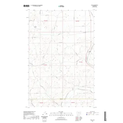
2020 Map of Plaza
USGS Topo · Published 2020About this map
Plaza stands at the eastern edge of this landscape, situated along the corridor of S Old Highway 195. This modern survey illustrates the transition from traditional transport routes to recreational use, most notably where the Palouse To Cascades State Park Trail follows the former rail grade across the southern portion of the sheet. The terrain is defined by a network of seasonal drainages, including Pine Creek, John Paulson Creek, and Buckeye Creek, which carve through the plateau. Local history is reflected in family-named routes such as S Patterson Rd, S Babb Rd, and S McDowell Rd, while the Wells Road Bridge provides a specific point of reference for researchers tracing the infrastructure of rural Spokane County and its border with Whitman County.
Find a feature on this map
46 named features on this map. Tap any name to fly to it.
Don’t see what you’re looking for? This feature index may not catch every label — zoom into the map to look around manually.
Map Details
Editions of this 2020 Plaza Map
This is the sole edition of this map. No revisions or reprints were ever made.
Other maps of this area

1903 · Oakesdale
USGS Topo · 1:125,000

1905 · Oakesdale
USGS Topo · 1:125,000

1954 · Cheney
USGS Topo · 1:62,500

1954 · Spangle
USGS Topo · 1:62,500

1955 · Spokane
USGS Topo · 1:250,000

1958 · Spokane
USGS Topo · 1:250,000

1964 · Malden
USGS Topo · 1:24,000
1964 · Rosalia
USGS Topo · 1:24,000

1964 · Pine City
USGS Topo · 1:24,000
1980 · Spangle West
USGS Topo · 1:24,000