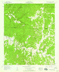
1957 Map of Pleasant Grove
USGS Topo · Published 1958About this map
Colbert Wildlife Refuge dominates the northern landscape of this mid-century survey, where the rugged terrain is defined by a dense network of creeks and branches flowing toward Cedar Creek. Small rural communities and isolated family homesteads characterize the area, with Pleasant Grove and Kimmons serving as local focal points. The map reveals a reliance on traditional water crossings and community institutions, as evidenced by Slickrock Ford, Burgess Bridge, and several country churches like Cedar Creek Church and Dunkin Center Ch. Genealogists will find significant value in the numerous family-named landmarks and cemeteries, such as Bolton Cem and Massey Cem, which pinpoint the locations of early area residents. The heavy concentration of springs like Smelser Spring and named hollows such as Dudley Hollow highlights the importance of the natural hydrology to the local settlement pattern during this era.
Find a feature on this map
48 named features on this map. Tap any name to fly to it.
Don’t see what you’re looking for? This feature index may not catch every label — zoom into the map to look around manually.
Map Details
Editions of this 1957 Pleasant Grove Map
3 editions found
Other maps of this area

1925 · Barton
USGS Topo · 1:62,500

1926 · Barton
USGS Topo · 1:48,000

1929 · Barton
USGS Topo · 1:62,500

1935 · Pleasant Site
USGS Topo · 1:24,000

1936 · Frankfort
USGS Topo · 1:24,000

1936 · Pleasant Grove
USGS Topo · 1:24,000

1936 · Isbell
USGS Topo · 1:24,000

1936 · Pride
USGS Topo · 1:24,000
1936 · Barton
USGS Topo · 1:24,000

1936 · Halltown
USGS Topo · 1:24,000