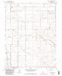
1967 Map of Pleasant Grove
USGS Topo · Published 1981About this map
The agricultural landscape of the Sutter and Placer County border is defined by its extensive drainage network and emerging infrastructure. This 1967 survey, with updates from 1981, shows the small settlement of Pleasant Grove at the intersection of Howsley Road and Pleasant Grove Road. The terrain is dissected by watercourses such as Auburn Ravine, King Slough, and Pleasant Grove Creek, which support the surrounding ranchlands. Industrial and military footprints are evident at the Lincoln Communication Annex (AF) and the KFBK Radio Towers. Transportation across the valley floor is facilitated by the Western Pacific and Sacramento Northern railroads, which parallel the Natomas East Main Drainage Canal near the southern border at Riego. A mix of established country lanes like Striplin Road and newer developments near Kaseburg reflect the region's gradual transition from open range to specialized use.
Find a feature on this map
35 named features on this map. Tap any name to fly to it.
Don’t see what you’re looking for? This feature index may not catch every label — zoom into the map to look around manually.
Map Details
Editions of this 1967 Pleasant Grove Map
2 editions found
Other maps of this area

1891 · Sacramento
USGS Topo · 1:125,000

1892 · Sacramento
USGS Topo · 1:125,000

1893 · Sacramento
USGS Topo · 1:125,000

1902 · Fairoaks
USGS Topo · 1:62,500

1907 · Davisville
USGS Topo · 1:62,500

1910 · Sheridan
USGS Topo · 1:31,680

1910 · Lincoln
USGS Topo · 1:31,680

1910 · Roseville
USGS Topo · 1:31,680

1910 · Vernon
USGS Topo · 1:31,680

1910 · Nicolaus
USGS Topo · 1:31,680