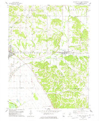
1978 Map of Pleasant Hill East
USGS Topo · Published 1978About this map
Pleasant Hill and Nebo serve as the primary anchors for this rural landscape in the late 1970s, situated near the boundary of Pike and Calhoun Counties. The terrain is defined by a dense network of creek valleys and ridges, where the Illinois Central Gulf railroad cuts through the heart of the quadrangle. Local family and community history is etched into the land through numerous small burial sites like Mason Cem, Hutton Hill Cem, and Neese Cem, often located near prominent elevations like Hutton Hill. To the southwest, the landscape flattens as it approaches the Mississippi River floodplain, marked by managed water features such as The Sny, a Diversion Levee, and the Crooked Slough. This transition from the dissected uplands of Martinsburg and Spring Creek to the bottomlands highlights the regional reliance on complex drainage systems to support the local agriculture and transportation networks of the era.
Find a feature on this map
42 named features on this map. Tap any name to fly to it.
Don’t see what you’re looking for? This feature index may not catch every label — zoom into the map to look around manually.
Map Details
Editions of this 1978 Pleasant Hill East Map
This is the sole edition of this map. No revisions or reprints were ever made.
Other maps of this area

1924 · Griggsville
USGS Topo · 1:62,500

1926 · Griggsville
USGS Topo · 1:62,500

1926 · Pittsfield
USGS Topo · 1:62,500

1930 · Pearl
USGS Topo · 1:62,500

1930 · Nebo
USGS Topo · 1:62,500

1934 · Nebo
USGS Topo · 1:48,000

1942 · Nebo
USGS Topo · 1:62,500

1948 · Quincy
USGS Topo · 1:250,000

1950 · Pearl
USGS Topo · 1:62,500

1956 · Quincy
USGS Topo · 1:250,000