
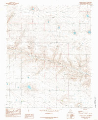
1985 Map of Pleasant Hill NW
USGS Topo · Published 1985About this map
Frio Draw cuts a prominent, winding path across this high plains landscape of Curry County, its complex drainage patterns contrasting with the rigid section lines of the surrounding territory. This 1985 survey, based on early 1980s field checks, reveals an environment where water management and energy infrastructure are central to land use. The presence of a Trans Line Wooden H-Frame and numerous Well sites across the sheet indicates the development of utility corridors and the essential reliance on groundwater in this arid region. To the south, the headwaters of Mustang Draw begin to take shape, showing the subtle topographic shifts that define the local watershed before the terrain settles into the flatter agricultural and grazing lands that characterize the High Plains.
Find a feature on this map
4 named features on this map. Tap any name to fly to it.
Don’t see what you’re looking for? This feature index may not catch every label — zoom into the map to look around manually.
Map Details
Editions of this 1985 Pleasant Hill NW Map
This is the sole edition of this map. No revisions or reprints were ever made.
Other maps of this area

1954 · Clovis
USGS Topo · 1:250,000

1957 · Pleasant Hill
USGS Topo · 1:62,500

1957 · Hammond Ranch
USGS Topo · 1:62,500

1958 · Clovis
USGS Topo · 1:250,000

1971 · Broadview
USGS Topo · 1:24,000

1971 · Grady
USGS Topo · 1:24,000

1971 · Bellview
USGS Topo · 1:24,000

1985 · Smith Ranch
USGS Topo · 1:24,000

1985 · Pleasant Hill
USGS Topo · 1:24,000
1985 · Garrett Ranch
USGS Topo · 1:24,000