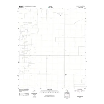
2010 Map of Pleasant Hill
USGS Topo · Published 2010About this map
Pleasant Hill and the settlement of Sligo anchor this landscape in the high plains of West Texas, where the terrain is defined by a grid of agricultural and oil-field access roads. The most prominent natural drainage is the ephemeral Sulphur Springs Draw, which cuts across the northern section of the quadrangle. The road network is heavily developed to support the local rural economy, with primary thoroughfares like Fm 213 and Taylor Rd providing connectivity between dispersed homesteads and industrial sites. This 2010 survey reflects a period of modern land management in Yoakum County, illustrating the precise rectangular surveying that characterizes the region. Researchers can trace the development of local infrastructure through the numerous numbered county roads, such as Co Rd 435 and Co Rd 385, which weave through the flat, semi-arid plains.
Find a feature on this map
18 named features on this map. Tap any name to fly to it.
Don’t see what you’re looking for? This feature index may not catch every label — zoom into the map to look around manually.
Map Details
Editions of this 2010 Pleasant Hill Map
This is the sole edition of this map. No revisions or reprints were ever made.
Other maps of this area

1954 · Hobbs
USGS Topo · 1:250,000

1954 · Brownfield
USGS Topo · 1:250,000

1958 · Brownfield
USGS Topo · 1:250,000

1958 · Hobbs
USGS Topo · 1:250,000

1962 · Brownfield
USGS Topo · 1:250,000

1970 · Seagraves
USGS Topo · 1:24,000

1970 · Tokio
USGS Topo · 1:24,000

1970 · Tokio NW
USGS Topo · 1:24,000
1970 · Tokio SE
USGS Topo · 1:24,000

1970 · Pleasant Hill
USGS Topo · 1:24,000