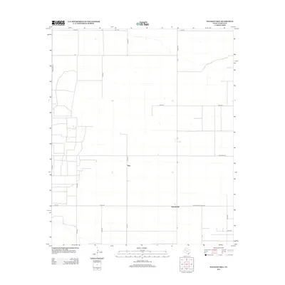
2012 Map of Pleasant Hill
USGS Topo · Published 2012About this map
Pleasant Hill and the small settlement of Sligo anchor this agricultural landscape in Yoakum County during the early 21st century. The map reveals a rigid rectilinear grid of section lines and rural transport routes that define West Texas ranching and farming operations. Major thoroughfares such as Farm-To-Market Road 330, Ranch Road 213, and Ranch Road 435 provide the primary connectivity across these wide-open plains. The map is characterized by a sparse distribution of structures and a complex web of local county roads, including Co Rd-385 and Co Rd-415, which serve isolated homesteads and agricultural plots. This survey captures the modern rural infrastructure of the region, where the intersection of large-scale land management and a sparse residential footprint is clearly visible through the meticulously charted road network.
Find a feature on this map
24 named features on this map. Tap any name to fly to it.
Don’t see what you’re looking for? This feature index may not catch every label — zoom into the map to look around manually.
Map Details
Editions of this 2012 Pleasant Hill Map
This is the sole edition of this map. No revisions or reprints were ever made.
Other maps of this area

1954 · Hobbs
USGS Topo · 1:250,000

1954 · Brownfield
USGS Topo · 1:250,000

1958 · Brownfield
USGS Topo · 1:250,000

1958 · Hobbs
USGS Topo · 1:250,000

1962 · Brownfield
USGS Topo · 1:250,000

1970 · Seagraves
USGS Topo · 1:24,000

1970 · Tokio
USGS Topo · 1:24,000

1970 · Tokio NW
USGS Topo · 1:24,000
1970 · Tokio SE
USGS Topo · 1:24,000

1970 · Pleasant Hill
USGS Topo · 1:24,000