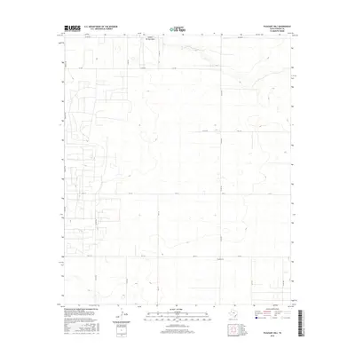
2016 Map of Pleasant Hill
USGS Topo · Published 2016About this map
Pleasant Hill sits at the heart of this High Plains landscape in Yoakum County, defined by a sparse but organized grid of rural roads and cattle country. The terrain is marked by subtle depressions and the prominent Sulphur Springs Draw, which cuts through the northern portion of the quadrangle. This ephemeral drainage feature indicates the region's hydraulic history and natural runoff patterns in an otherwise semi-arid environment. The road network, including Bennett Rd and FM 213, follows the rigid section lines typical of West Texas land surveying, connecting isolated farmsteads and agricultural operations. The map provides a precise look at the rural infrastructure of the 2010s, showing how modern transportation routes like FM 330 and various county roads overlay the historical cattle-ranching territory of the South Plains.
Find a feature on this map
19 named features on this map. Tap any name to fly to it.
Don’t see what you’re looking for? This feature index may not catch every label — zoom into the map to look around manually.
Map Details
Editions of this 2016 Pleasant Hill Map
This is the sole edition of this map. No revisions or reprints were ever made.
Other maps of this area

1954 · Hobbs
USGS Topo · 1:250,000

1954 · Brownfield
USGS Topo · 1:250,000

1958 · Brownfield
USGS Topo · 1:250,000

1958 · Hobbs
USGS Topo · 1:250,000

1962 · Brownfield
USGS Topo · 1:250,000

1970 · Seagraves
USGS Topo · 1:24,000

1970 · Tokio
USGS Topo · 1:24,000

1970 · Tokio NW
USGS Topo · 1:24,000
1970 · Tokio SE
USGS Topo · 1:24,000

1970 · Pleasant Hill
USGS Topo · 1:24,000