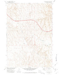
1972 Map of Ploessers Draw
USGS Topo · Published 1975About this map
Schoonover Divide Road traverses the high ground of Johnson County, providing a glimpse into the isolated ranching and water-management systems of the early 1970s. The landscape is defined by a series of north-draining ephemeral channels, most notably Ploessers Draw and Indian Creek Draw. Human activity in this arid basin is concentrated around water catchments like Indian Creek Reservoir, Green Reservoir, and Alexander Reservoir, which support the operations of the Indian Creek Ranch. A significant industrial corridor is marked by a Pipeline cutting through the center of the sheet. The prevalence of these man-made reservoirs alongside natural features like Ploessers Dry Lake underscores the vital role of water infrastructure in sustaining this portion of the Missouri River Basin during the late twentieth century.
Find a feature on this map
15 named features on this map. Tap any name to fly to it.
Don’t see what you’re looking for? This feature index may not catch every label — zoom into the map to look around manually.
Map Details
Editions of this 1972 Ploessers Draw Map
This is the sole edition of this map. No revisions or reprints were ever made.
Other maps of this area

1955 · Sheridan
USGS Topo · 1:250,000

1958 · Sheridan
USGS Topo · 1:250,000

1962 · Sheridan
USGS Topo · 1:250,000
1972 · Crazy Woman Ranch
USGS Topo · 1:24,000
1972 · Pine Gulch
USGS Topo · 1:24,000
1972 · Bear Draw
USGS Topo · 1:24,000
1972 · Somerville Flats West
USGS Topo · 1:24,000
1972 · Brown Ranch
USGS Topo · 1:24,000
1972 · Bowman Flat
USGS Topo · 1:24,000
1972 · Juniper Draw
USGS Topo · 1:24,000