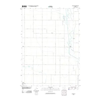
2010 Map of Plover
USGS Topo · Published 2010About this map
Plover serves as the primary hub of activity in this rural Iowa landscape, featuring the Plover Post Office at the heart of the settlement. The town is situated on a grid of section roads that extend across the agricultural plains of Pocahontas County, illustrating the systematic land division of the Midwest. The terrain is defined by the winding course of the Des Moines River, which flows through the eastern portion of the quadrangle alongside the River Runner Access. This riparian corridor provides a distinct contrast to the surrounding farmland, which is further drained by tributaries like Beaver Creek and Cylinder Creek. Several burial grounds, including Lincoln Cemetery, Riverside Cemetery, and Ellington Cemetery, are scattered across the township lines, offering significant points of interest for genealogists and local historians tracing the heritage of the region's farming families.
Find a feature on this map
38 named features on this map. Tap any name to fly to it.
Don’t see what you’re looking for? This feature index may not catch every label — zoom into the map to look around manually.
Map Details
Editions of this 2010 Plover Map
This is the sole edition of this map. No revisions or reprints were ever made.
Other maps of this area

1954 · Fairmont
USGS Topo · 1:250,000

1954 · Fort Dodge
USGS Topo · 1:250,000

1957 · Fort Dodge
USGS Topo · 1:250,000

1958 · Fort Dodge
USGS Topo · 1:250,000

1958 · Fairmont
USGS Topo · 1:250,000

1980 · Rolfe
USGS Topo · 1:24,000

1980 · Havelock
USGS Topo · 1:24,000
1980 · Mallard
USGS Topo · 1:24,000

1980 · Plover
USGS Topo · 1:24,000
1980 · Emmetsburg
USGS Topo · 1:24,000