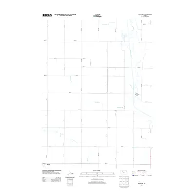
2013 Map of Plover
USGS Topo · Published 2013About this map
The town of Plover anchors the southwestern corner of this Pocahontas County landscape, which is defined by a rigorous grid of section-line roads and an intricate hydrological network. The Des Moines River winds southward through the eastern half of the map, providing a natural contrast to the strictly straight lines of the surrounding agricultural land. Public recreation is noted at the River Runner Access along the riverbank, while the territory is drained by several named watercourses including Cylinder Cr, Beaver Cr, and engineered channels like Ditch Number 123, Ditch Number 48, and Ditch Number 17. This drainage infrastructure, typical of the region, illustrates the intensive management of the Iowa plains to support its expansive farming economy.
Find a feature on this map
41 named features on this map. Tap any name to fly to it.
Don’t see what you’re looking for? This feature index may not catch every label — zoom into the map to look around manually.
Map Details
Editions of this 2013 Plover Map
This is the sole edition of this map. No revisions or reprints were ever made.
Other maps of this area

1954 · Fairmont
USGS Topo · 1:250,000

1954 · Fort Dodge
USGS Topo · 1:250,000

1957 · Fort Dodge
USGS Topo · 1:250,000

1958 · Fort Dodge
USGS Topo · 1:250,000

1958 · Fairmont
USGS Topo · 1:250,000

1980 · Rolfe
USGS Topo · 1:24,000

1980 · Havelock
USGS Topo · 1:24,000
1980 · Mallard
USGS Topo · 1:24,000

1980 · Plover
USGS Topo · 1:24,000
1980 · Emmetsburg
USGS Topo · 1:24,000