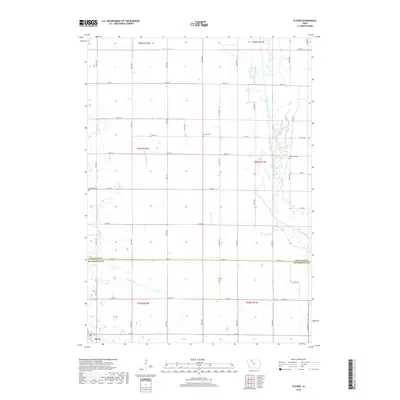
2018 Map of Plover
USGS Topo · Published 2018About this map
The town of Plover anchors the southwestern corner of this survey, where the grid of rural roads meets the county line between Palo Alto and Pocahontas Counties. This landscape is defined by the extensive drainage network supporting local agriculture, including Ditch Number 123, Ditch Number 48, and Ditch Number 17, which feed into natural watercourses like Cylinder Creek and Beaver Cr. In the east, the Des Moines River carves a winding path through the prairie, its banks marked by the Riverside Cem. Several other burial grounds, including Lincoln Cem and Ellington Cem, provide specific points of interest for genealogists tracing early families in these rural townships. The map documents a meticulously surveyed section of Iowa, showing the relationship between small-town settlement and the engineering of the surrounding watershed.
Find a feature on this map
31 named features on this map. Tap any name to fly to it.
Don’t see what you’re looking for? This feature index may not catch every label — zoom into the map to look around manually.
Map Details
Editions of this 2018 Plover Map
This is the sole edition of this map. No revisions or reprints were ever made.
Other maps of this area

1954 · Fairmont
USGS Topo · 1:250,000

1954 · Fort Dodge
USGS Topo · 1:250,000

1957 · Fort Dodge
USGS Topo · 1:250,000

1958 · Fort Dodge
USGS Topo · 1:250,000

1958 · Fairmont
USGS Topo · 1:250,000

1980 · Rolfe
USGS Topo · 1:24,000

1980 · Havelock
USGS Topo · 1:24,000
1980 · Mallard
USGS Topo · 1:24,000

1980 · Plover
USGS Topo · 1:24,000
1980 · Emmetsburg
USGS Topo · 1:24,000